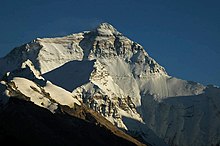
中國—尼泊爾邊界

中國—尼泊爾邊界是中國西藏自治區與尼泊爾的邊界,全長1389公里,以西北-東南方向喜馬拉雅山脈而行,包括世界最高山珠穆朗瑪峰[1]。此邊界隨時間不斷改變。1956年《中尼友好協議》和1960年《中尼和平友好條約》的簽訂後,尼泊爾承認西藏為中國領土,並確認了中尼兩國的範圍[2][3]。
概覽
[编辑]
邊界由遠西省近亭加山口與印度的西端三角點開始[4]向東南到烏拉山口,轉向東北,並沿格爾納利河而行,在拉普齊山口轉向東南。之後再前往喜瑪拉雅山脈的山峰前進,包括珠穆朗瑪峰、馬卡魯峰及戈乃斯山,以及一系列山口[5],並以瓊桑峰的東端三角點結束[5]。
歷史
[编辑]邊界範圍向來都是尼泊爾、印度和西藏等王國的邊緣地帶[5]。尼泊爾和西藏的跨境貿易已持續幾個世紀,包括羊毛、茶、香料及鹽[6][7]。雖然18至19世紀期間有許多尼泊爾和西藏的條約簽訂,該些條約對領土一般只作模楜處理而非劃定準確的邊界[5]。
1950至1951年西藏和平解放時繼承了中尼邊界的混亂[8]。1960年3月21日簽訂了邊界條約,承認傳統習慣線並設立了聯合邊界小組以劃定更準確的邊界[5]。邊界劃定完成後,1961年10月5日簽訂最終《中尼邊界條約》[5]。邊界隨後以地上列柱劃定,最終議定書在1963年1月23日簽訂[5]。
雖然尼泊爾和中國沒有領土爭議,西部中尼印三角點在尼泊爾和印度則有領土爭議。2015年,尼泊爾國會拒絕中國與印度通過里普列克山口進行貿易的協議,稱其「違反尼泊爾對爭議地區的主權」[9]。印度總理納倫德拉·莫迪2015年訪華後,中印同意在里普列克山口開設貿易站,引來尼泊爾的反對[10][11]。尼泊爾期望與印度以外交途經解決爭端[12]。
跨境口岸
[编辑]2012年,中尼兩國同意開放新的口岸至6個,其中3個為國際口岸,其餘3個只作雙邊貿易用途[13]。
中尼公路上的樟木镇與科達里口岸自1968年已開放使用[14]。2014年,在吉隆鎮的口岸開放商業用途,2017年再開放予外國人[6][15][16]。另外,中尼鐵路亦計劃通過此口岸過境。
其他口岸如靠近西端三角點的普蘭鎮口岸,雖交通不便,但已作為中尼貿易通道多年[17]。部分口岸非常重要,2008年中國收緊邊界管制期間,基瑪塘等村莊一度面臨食物短缺的地步[18]。歷史上曾有更多的口岸。木斯塘王國與西藏在科里山口的口岸曾是藏尼鹽貿路線,但1960年代因西藏游擊隊活躍而關閉,至今大部分時間仍然關閉,只在半年一度的跨境貿易展覽開放作有限度本地貿易[6]。
| 條約名稱[13](Other Name) | 行政區[13] | 狀態 | 國際跨境 | 口岸位置 | 邊界海拔 | 西藏自治區最高海拔 | 備註 |
|---|---|---|---|---|---|---|---|
| 普蘭–雅犁(斜尔瓦[19]) | 普蘭縣普蘭鎮 胡姆拉縣希爾薩 |
活跃 | 计划 | 30°09′12″N 81°20′00″E / 30.15333°N 81.33333°E | 3,640米(11,900英尺) | 4,720米(15,500英尺) | 現時有本地貿易 |
| 里孜—乃琼(科里山口) | 仲巴县亚热乡 木斯塘Lo Manthang |
计划 | 否 | 29°19′24″N 83°59′09″E / 29.32333°N 83.98583°E | 4,620米(15,200英尺) | 現有季節性貿易展 | |
| 吉隆–热索瓦 | 吉隆县吉隆镇 拉苏瓦县拉苏瓦堡 |
活跃 | 是 | 28°16′45″N 85°22′43″E / 28.27917°N 85.37861°E | 1,850米(6,100英尺) | 5,230米(17,200英尺) | |
| 樟木–科達里 | 聶拉木縣樟木鎮 辛杜帕爾喬克縣塔托帕尼鄉 |
活跃[20] | 是 | 27°58′24″N 85°57′50″E / 27.97333°N 85.96389°E | 1,760米(5,800英尺) | 5,150米(16,900英尺) | |
| 陳塘–吉马塘卡 | 定結縣陳塘鎮 桑庫瓦沙巴縣吉曼坦卡 |
计划 | 否 | 27°51′30″N 87°25′30″E / 27.85833°N 87.42500°E | 2,248米(7,400英尺) | 現有本地貿易 | |
| 日屋–瓦隆琼果拉(Tipta La) | 定結縣日屋鎮 塔普勒瓊縣Olangchung Gola |
计划 | 否 | 27°49′00″N 87°44′00″E / 27.81667°N 87.73333°E | 5,095米(16,700英尺) | 現有本地貿易 |
圖片
[编辑]-
吉隆口岸
-
樟木口岸的中尼友誼橋
-
普蘭口岸的山口
參見
[编辑]參考資料
[编辑]- ^ Nepal. CIA World Factbook. [23 September 2020]. (原始内容存档于2020-09-05).
- ^ Van Tronder, Gerry. Sino-Indian War: Border Clash: October–November 1962. Pen and Sword Military. 2018 [2020-10-15]. ISBN 9781526728388. (原始内容存档于2020-10-20).
- ^ Adhikari, Monalisa. Between the Dragon and the Elephant: Nepal's Neutrality Conundrum. Indian Journal of Asian Affairs. 2012, 25 (1/2): 85. JSTOR 41950522.
- ^ Cowan, Sam, The Indian checkposts, Lipu Lekh, and Kalapani, School of Oriental and African Studies: 16–17, 2015 [2020-10-15], (原始内容存档于2020-12-03)
- ^ 5.0 5.1 5.2 5.3 5.4 5.5 5.6 Office of the Geographer, International Boundary Study - China – Nepal Boundary (PDF), Bureau of Intelligence and Research, US Department of State, 1965-05-30 [2017-02-14], (原始内容 (PDF)存档于2012-05-03)
- ^ 6.0 6.1 6.2 Murton, Galen. A Himalayan Border Trilogy: The Political Economies of Transport Infrastructure and Disaster Relief between China and Nepal. Cross-Currents E-Journal. March 2016 [2017-02-09]. ISSN 2158-9674. (原始内容存档于2020-11-24).
- ^ Eede, Joanna. Nomads of Dolpo. National Geographic Voices. National Geographic. 2015-06-12 [2017-02-10]. (原始内容存档于2017-07-06).
- ^ Office of the Geographer (1965): "The exact number of territorial disputes has never been ascertained, but as many as 20 sectors may have been involved. The most serious disputes were located at Rasu (north of Katmandu), Kimathanka in the east, Nara Pass, Tingribode near Mustang, Mount Everest, and the Nelu River. Most of these disputes were settled in favor of Nepal, although several favored China."
- ^ Nepal objects to India-China trade pact via Lipu-Lekh Pass (页面存档备份,存于互联网档案馆), The Economic Times, 9 June 2015.
- ^ Resolve Lipu-Lekh Pass dispute: House panel to govt, Republica, 28 June 2018 [2020-10-15], (原始内容存档于2018-06-28)
- ^ Ekantipur Report. Lipulekh dispute: UCPN (M) writes to PM Koirala, Indian PM Modi & Chinese Prez Xi. Kathmandu Post. July 9, 2015 [13 January 2020]. (原始内容存档于2020-10-29).
- ^ Post-J&K map ache spreads to Nepal. Telegraph India. 8 November 2019 [15 November 2019]. (原始内容存档于2020-11-01).
- ^ 13.0 13.1 13.2 中华人民共和国政府和尼泊尔政府关于边境口岸及其管理制度的协定 [China-Nepal Agreement on Port of Entry]. Chinese Embassy in Nepal. 2012-01-14 [2017-02-10]. (原始内容存档于2020-10-19) (中文).
- ^ Buddhi Narayan Shrestha. Nepal-China Seven Border Crossing-points. Border Nepal Buddhi. 2015-11-29 [2017-02-09]. (原始内容存档于2020-10-19).
Kodari-Khasa has been in operation since 1968 for the transaction of trade and commerce. The second commercial border-point is the Rasuwagadhi-Kerung, which has come into use recently.
- ^ Lobsang. Tibet Nepal Border Closedsalt. The Land of Snows. 2016-06-25 [2017-02-09]. (原始内容存档于2017-02-11).
the new border crossing from Kyirong, Tibet to Rasuwaghadi, Nepal. Though this border crossing has NOT been opened to foreign travelers yet, this route has been open to traders from Nepal and China for much of the past year...
- ^ Tenphel, Sonam. Gyirong Port, new Sino-Nepal Border Finally was Opened, so Lhasa and Kathmandu Overland Tour is all Available Now. Tibet Vista. [26 November 2017]. (原始内容存档于2020-10-17).
- ^ Prithvi Man Shrestha; Jaya Bahadur Rokaya. Nepal, China rush to open Hilsa border. Kathmandu Post. 2016-03-24 [2017-02-10]. (原始内容存档于2018-12-11).
Hilsa is one of the six border points Nepal and China had agreed to open for international trade when former Chinese Prime Minister Wen Jibao visited Kathmandu in 2012.
- ^ Budhathoki, Kishor. China seals border, villages on Nepali side face starvation. The Himalayan Times. 2008-06-04 [2017-02-13]. (原始内容存档于2020-10-17).
Starvation looms large in the northern parts of Sankhuwasabha district after China closed the Kimathanka check post
- ^ News from China (PDF). Chinese Embassy in India. Vol. XXVIII no. 7. July 2016 [2017-02-15]. (原始内容存档 (PDF)于2019-07-13).
- ^ Kodari Checkpoint To Open Today. The Spotlight Online. 2019-05-29 [2019-06-28]. (原始内容存档于2020-10-19).
參考文獻
[编辑]- Tiwary, Chitra K., China–Nepal Border: Potential Hot Spot?, Bruce Elleman; Stephen Kotkin; Clive Schofield (编), Beijing's Power and China's Borders: Twenty Neighbors in Asia, Taylor and Francis: 205–, 2012 [2020-10-15], ISBN 9781317515647, (原始内容存档于2020-10-20)
外部連結
[编辑] 中华人民共和国和尼泊尔王国边界条约. 维基文库. 1961-10-05 (中文).


