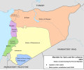
File:French Mandate for Syria and the Lebanon map en.svg
外观

此SVG文件的PNG预览的大小:725 × 599像素。 其他分辨率:290 × 240像素 | 581 × 480像素 | 929 × 768像素 | 1,239 × 1,024像素 | 2,478 × 2,048像素 | 922 × 762像素。
原始文件 (SVG文件,尺寸为922 × 762像素,文件大小:245 KB)
文件历史
点击某个日期/时间查看对应时刻的文件。
| 日期/时间 | 缩略图 | 大小 | 用户 | 备注 | |
|---|---|---|---|---|---|
| 当前 | 2013年2月4日 (一) 16:05 |  | 922 × 762(245 KB) | AnonMoos | Change "Libanon" to "Lebanon" |
| 2013年2月4日 (一) 15:33 |  | 922 × 762(250 KB) | Don-kun | fix border to palestine, source: http://en.wikisource.org/wiki/Franco-British_Convention_on_Certain_Points_Connected_with_the_Mandates_for_Syria_and_the_Lebanon,_Palestine_and_Mesopotamia | |
| 2013年1月30日 (三) 18:43 |  | 922 × 762(248 KB) | Don-kun | minus ahistorical lakes (and so all waterbodies) | |
| 2013年1月26日 (六) 21:44 |  | 922 × 762(282 KB) | Don-kun | {{Information |Description ={{en|1=Map of French Mandate for Syria and the Lebanon and the states created in 1922, in English.}} |Source ={{own}}, based on File:Syria, administrative divisions - de - colored.svg |Author =[[User:... |
文件用途
以下4个页面使用本文件:
全域文件用途
以下其他wiki使用此文件:
- af.wikipedia.org上的用途
- ar.wikipedia.org上的用途
- ast.wikipedia.org上的用途
- azb.wikipedia.org上的用途
- az.wikipedia.org上的用途
- be-tarask.wikipedia.org上的用途
- be.wikipedia.org上的用途
- bg.wikipedia.org上的用途
- bn.wikipedia.org上的用途
- cs.wikipedia.org上的用途
- de.wikipedia.org上的用途
- el.wikipedia.org上的用途
- en.wikipedia.org上的用途
查看此文件的更多全域用途。


