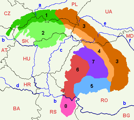
File:Mapcarpat2.png
外觀
Mapcarpat2.png (442 × 395 像素,檔案大小:11 KB,MIME 類型:image/png)
檔案歷史
點選日期/時間以檢視該時間的檔案版本。
| 日期/時間 | 縮圖 | 尺寸 | 用戶 | 備註 | |
|---|---|---|---|---|---|
| 目前 | 2021年4月7日 (三) 17:58 |  | 442 × 395(11 KB) | C.Ezra.M | Changes: BH -> BA, fixed font for MD |
| 2021年4月7日 (三) 17:56 |  | 442 × 395(11 KB) | C.Ezra.M | Reverted to version as of 17:45, 6 January 2019 (UTC) cuz forgot to specify the actual changes | |
| 2021年4月7日 (三) 17:52 |  | 442 × 395(11 KB) | C.Ezra.M | changes: | |
| 2019年1月6日 (日) 17:45 |  | 442 × 395(11 KB) | Julieta39 | Add MD | |
| 2014年2月1日 (六) 00:10 |  | 442 × 395(12 KB) | Olahus | Small changes on Austria, Romania and Serbia. | |
| 2007年5月24日 (四) 08:23 |  | 442 × 395(12 KB) | Zeman | {{Information |Description= |Source=self-made |Date= |Author= User:Zeman }} | |
| 2005年7月12日 (二) 11:52 |  | 442 × 395(9 KB) | Markussep | ISO 3166-1 alpha-2 country codes | |
| 2005年7月12日 (二) 11:32 |  | 442 × 395(9 KB) | Markussep | Annotated version of image file Mapcarpat.png |
檔案用途
下列頁面有用到此檔案:
全域檔案使用狀況
以下其他 wiki 使用了這個檔案:
- als.wikipedia.org 的使用狀況
- ar.wikipedia.org 的使用狀況
- arz.wikipedia.org 的使用狀況
- ast.wikipedia.org 的使用狀況
- ba.wikipedia.org 的使用狀況
- be-tarask.wikipedia.org 的使用狀況
- be.wikipedia.org 的使用狀況
- bg.wikipedia.org 的使用狀況
- bn.wikipedia.org 的使用狀況
- bs.wikipedia.org 的使用狀況
- ca.wikipedia.org 的使用狀況
- cs.wikipedia.org 的使用狀況
- da.wikipedia.org 的使用狀況
- de.wikipedia.org 的使用狀況
- de.wiktionary.org 的使用狀況
- el.wikipedia.org 的使用狀況
- en.wikipedia.org 的使用狀況
- Central Europe
- Carpathian Mountains
- Bucegi Mountains
- Outer Subcarpathia
- Southern Carpathians
- Apuseni Mountains
- Divisions of the Carpathians
- Talk:Divisions of the Carpathians
- Transylvanian Plateau
- Slovak Ore Mountains
- Retezat-Godeanu Mountains group
- Parâng Mountains group
- Făgăraș Mountains group
- Western Carpathians
- North Hungarian Mountains
- Northern Maramureș
- Talk:Northern Maramureș
- Eastern section of the Western Beskids
- Template:Inner North-Eastern Carpathians
檢視此檔案的更多全域使用狀況。


