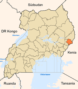
卡普喬魯瓦區
外观
| 卡普喬魯瓦區 | |
|---|---|
 2010年以後的卡普喬魯瓦區範圍以紅色標示 | |
| 坐标:1°20′N 34°34′E / 1.33°N 34.57°E | |
| 國家 | |
| 地理區 | 東部區 |
| 首府 | 卡普喬魯瓦 |
| 海拔 | 1,800 公尺(5,900 英尺) |
| 人口(2014年普查) | |
| • 總計 | 104,580人 |
| 时区 | 東非時間(UTC+3) |
| 網站 | www |
卡普喬魯瓦區是非洲中部國家烏干達的一個區,由東部區負責管轄,首府是卡普喬魯瓦,海拔高度1,800米,距離姆巴萊約65公里,主要的經濟產業有自給農業和畜牧業。2014年普查人口為104,580。[1]
2005年,布克瓦區自本區析出。2010年,奎恩區自本區析出。

參考文獻
[编辑]- ^ UBOS. The population of the regions and districts of Uganda according to census results and latest official projections. Citypopulation.de Quoting Uganda Bureau of Statistics (UBOS). 2014-08-27 [2016-01-03]. (原始内容存档于2016-02-27).
外部連結
[编辑]- Kapchorwa District Homepage
- Kapchorwa District Profile at Ugandatravelguide.com(页面存档备份,存于互联网档案馆)
- Cattle Rustling In The Great Lakes Region by Saul Chemonges Kasumbein[永久失效連結]
| 这是一篇与乌干达相关的小作品。您可以通过编辑或修订扩充其内容。 |

