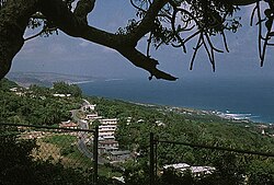
聖約翰區 (巴貝多)
外觀
此條目沒有列出任何參考或來源。 (2018年5月25日) |
| 聖約翰區 | |
|---|---|
| 區 | |
 | |
 Map of Barbados showing the Saint John parish | |
| 坐標:13°10′N 59°29′W / 13.167°N 59.483°W | |
| 國家 | 巴巴多斯 |
| 最大村莊 | 福羅茲 |
| 政府 | |
| • 類型 | 代議民主制 |
| • 議會席位 | 1 |
| 面積 | |
| • 總計 | 34 平方公里(13 平方英里) |
| 人口(2010年普查) | |
| • 總計 | 8,963人 |
| • 密度 | 264人/平方公里(683人/平方英里) |
| ISO 3166碼 | BB-05[1] |
聖約翰區(Saint John)位於巴貝多中南,與聖喬治區、聖約瑟夫區、聖菲利普區等區相鄰。
| 這是一篇與加勒比海相關的小作品。您可以透過編輯或修訂擴充其內容。 |
- ^ iso:code:3166:BB, International Organization for Standardization
