聖詹姆斯區 (巴貝多)
外觀
| Saint James | |
|---|---|
| 行政區劃 | |
 | |
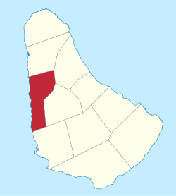
 Map of Barbados showing the Saint James parish | |
| 坐標:13°13′N 59°37′W / 13.217°N 59.617°W | |
| 國家 | 巴巴多斯 |
| 最大城市 | 霍爾敦 |
| 政府 | |
| • 類型 | Parliamentary democracy |
| • 議會席位 | 3 |
| 面積 | |
| • 總計 | 31 平方公里(12 平方英里) |
| 人口(2010 census) | |
| • 總計 | 28,498人 |
| • 密度 | 919人/平方公里(2,381人/平方英里) |
| ISO 3166碼 | BB-04[1] |
聖詹姆斯區位於巴貝多中西部,與聖安德魯、聖邁克爾區、聖彼得區、聖托馬斯區等區相鄰。該處被譽為富豪及名人的後花園,亦是渴求日光浴的人的避風港[2]。
參考
[編輯]- ^ iso:code:3166:BB (頁面存檔備份,存於網際網路檔案館), International Organization for Standardization
- ^ Tyzack, Anna. Property in the Caribbean: Welcome to Barbados. The Daily Telegraph. 19 February 2010 [24 June 2010]. (原始內容存檔於2013-01-16).
| 這是一篇與加勒比海相關的小作品。您可以透過編輯或修訂擴充其內容。 |
