卡里布-塔基国家森林
外观
| Caribou-Targhee National Forest 卡里布-塔基国家森林 | |
|---|---|
IUCN分类VI(资源管理保护区) | |
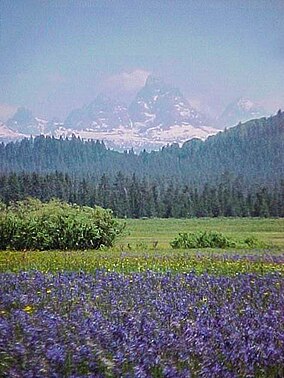
 Camas flowers and the west vista of the Teton Range from Caribou-Targhee National Forest | |
| 位置 | 美国爱达荷州、怀俄明州、犹他州 |
| 最近城市 | 波卡特洛 |
| 坐标 | 42°47′0″N 111°33′0″W / 42.78333°N 111.55000°W |
| 面积 | 2,630,716英亩(10,646.13平方千米)[1] |
| 建立 | 1903年 |
| 管理机构 | 美国国家森林局 |
| 网站 | Caribou-Targhee National Forest |
卡里布-塔基国家森林(英语:Caribou-Targhee National Forest)是美国的一处国家森林,1903年建立,位处怀俄明州、爱达荷州(犹他州也有一小部分),占地面积超过2.63 × 10⁶英亩(10.6 × 10³平方千米),最近的城市为波卡特洛。
参考资料
[编辑]- ^ Land Areas of the National Forest System (PDF). U.S. Forest Service. January 2012 [June 30, 2012]. (原始内容存档 (PDF)于2012-11-01).
外部链接
[编辑]维基共享资源上的相关多媒体资源:卡里布-塔基国家森林
- "Caribou National Forest-Montpelier Ranger District-Montpelier Watershed Analysis"[永久失效链接]
- "Lumber, Stone & Concrete", Administrative Facilities of the Caribou-Targhee National Forests, 1891-1955 (页面存档备份,存于互联网档案馆)
- Caribou-Targhee National Forest. U.S. Forest Service. [2006-07-08]. (原始内容存档于2020-12-15).
| 这是一篇与美国地理相关的小作品。您可以通过编辑或修订扩充其内容。 |

